

The first time you see them, it almost feels like a trick of light.
From a roadside pull-off, the land looks cracked with silver veins, spreading wide across black sand.
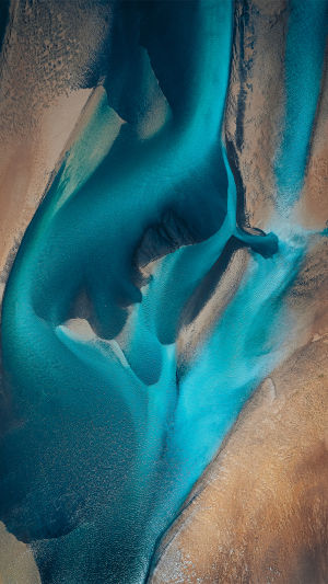
No single river. No clear channel. Just water dividing and rejoining over and over again. Iceland's braided rivers aren't dramatic waterfalls or towering cliffs—but they might be the most dynamic landscapes you'll encounter on the island.
If you slow down and really look, you'll notice something important: they're always changing.
<h3>Where to See the Most Striking Braided Rivers</h3>
The largest and most photogenic braided systems are found along the south coast, especially near the vast outwash plains fed by glaciers.
One of the best areas is Skeiðarársandur, a massive sandur plain formed by meltwater from Vatnajökull, Europe's largest glacier by volume. This isn't a single viewpoint—it's an entire region where rivers fan out into dozens of shifting channels.
<b>Here's how to experience it well:</b>
Drive along the Ring Road (Route 1) between Kirkjubæjarklaustur and Höfn. Several bridges cross braided rivers, offering safe roadside stops.
Pull into marked viewpoints before crossing major bridges. You'll often find gravel parking areas with clear sightlines.
If conditions allow, book a small sightseeing flight from Skaftafell or Höfn (typically $250–$400 USD per person for 45–60 minutes). From the air, the braided patterns look like abstract art.
Best time to visit? Late June through August. That's when glacial melt is strongest, and the channels are most active. Go early in the morning—before 9 a.m.—for softer light and fewer tour buses stopping at the same bridges.
<h3>Why These Rivers Look So Different</h3>
Most rivers you've seen probably follow one deep channel. Braided rivers don't behave that way. They form when three conditions come together:
High sediment load (lots of sand and gravel in the water).
Steady slope but relatively flat terrain.
Fluctuating water flow, especially from glacier melt.
In Iceland, glaciers grind rock into fine sediment as they move. When meltwater carries that material downstream, it spreads out over wide plains. As the water slows, it drops sediment. Gravel builds up. Channels clog. The river splits and finds another path.
The result? Multiple shallow streams weaving around temporary islands.
If you visit in early spring, the rivers may appear narrower. In mid-summer, they often expand dramatically. The same stretch of sand can look completely different within weeks.
Actionable tip: Compare satellite maps before and after your trip. You'll likely notice that some channels visible in older images no longer exist in the same place.
<h3>How to Photograph Braided Rivers Well</h3>
Many travelers stop, take a quick photo from the bridge, and move on. But braided rivers reward patience.
<b>Here's how to capture them better:</b>
Look for elevation. Even small hills near parking areas provide better angles than flat roadside shots.
Shoot during low sun (early morning or late evening). The side lighting enhances texture in the gravel bars.
Focus on patterns, not scale. Zoom slightly to emphasize the weaving shapes rather than trying to capture the entire plain.
If you're flying a drone, always check local regulations first. In many protected areas near glaciers, drone use is restricted.
One simple trick: wait a few minutes before taking photos. Watch how the light shifts on the water. The silver tones become more pronounced as clouds move.
<h3>What to Know Before Exploring Nearby</h3>
Braided rivers look shallow—and many sections are—but they can be unpredictable. Channels may deepen quickly during warm afternoons when glacial melt increases.
<b>Keep these safety principles in mind:</b>
Never attempt to drive across unmarked river crossings unless you're experienced and have a proper 4x4 vehicle.
Check daily road conditions at road.is before entering highland areas.
Avoid walking far onto wet gravel bars. The ground can be unstable and saturated beneath the surface.
Highland roads (marked with “F”) typically open between late June and early July and close by September, depending on weather. Outside that window, access is often restricted.
If you want to walk closer to a braided system safely, choose marked trails near Skaftafell Nature Reserve (entrance free, parking approximately $7 USD per day). Trails there provide elevated views without putting you in unstable terrain.
<h3>Why They're Worth Slowing Down For</h3>
It's easy to focus on Iceland's famous waterfalls and overlook the quiet drama of braided rivers. But these landscapes show something deeper: constant motion without noise. No crashing falls. No roaring surf. Just steady rearrangement.
Stand still for ten minutes on a bridge and watch carefully. You'll see subtle shifts in flow. Tiny channels strengthening. Others fading. It's geography happening in real time.
That's what makes braided rivers so compelling. They aren't monuments. They're processes.
If you're planning a south coast drive, build in at least one unhurried stop just for them. Not a five-minute photo break—an actual pause. Bring a windproof jacket, lean on the railing, and let your eyes adjust to the patterns.
Most people drive past too quickly.
But if you give these silver threads a little time, you'll start to see the landscape differently—not as something fixed, but as something constantly rewriting itself. And once you notice that, every river crossing feels like a front-row seat to change in motion.